Drone Photography
Drone Photography
Waynesboro & Staunton, VA
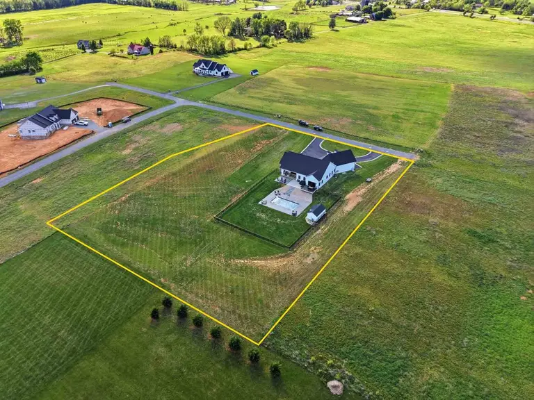
Show them what no ground shot can. FAA-certified pilots. High-resolution aerial photography that captures land boundaries, neighborhood context, mountain views, and everything that makes a property's location worth buying. Delivered alongside your ground photos.
Why it matters
What aerial photography shows
that ground shots cannot.
No Liability Risk for You
Villa Views carries FAA Part 107 certification on every shoot. You get professional aerial photography with zero compliance exposure on your end.
Shows What Ground Shots Miss
Lot size, acreage, proximity to amenities, mountain or water views - buyers making decisions from out of town need aerial context.
Shenandoah Valley Expertise
We know the local airspace, flight windows, and how to shoot Blue Ridge backdrops at the right angle and light.
Coordinated with Ground Media
Drone and ground photography are shot in the same visit so your full gallery is cohesive and delivered together.
Weather-Flexible Scheduling
We monitor conditions and coordinate rescheduling at no extra cost if weather grounds the drone on shoot day.
Files Ready for Wherever You Need Them
Full-resolution files sized for MLS, print, and digital marketing - delivered through your portal and ready to use immediately.
Pricing
Aerial photography pricing
add-on or standalone.
All packages include online delivery via the Villa Views portal. Pay at Close available →
Drone Add-On
$95
Added to any photography booking - 5–8 images
- 5–8 aerial images
- Added to existing photo order
- Single-visit coordination
- FAA-certified pilot
- Delivered with photo package
Drone Standalone
$150
Drone-only shoot - 5–8 aerial images
- 5–8 edited aerial images
- Property & context coverage
- FAA-certified pilot
- Online delivery within 24 hours
- MLS-ready file sizes
GIS Property Outline
$10
Add-on · Properties under 20 acres only
- GIS data property line overlay
- Applied to one aerial image
- Not survey-accurate
- Available on properties under 20 acres
- Included free with Essentials & Premier packages
Land only
Photographing raw land or an unimproved lot rather than a house? That is priced by acreage instead of square footage.
Common questions
Questions agents ask
about drone photography.
Yes. All Villa Views drone pilots hold FAA Part 107 Remote Pilot Certificates. We handle airspace authorization and any required waivers.
Light overcast can actually work well for aerials - it reduces harsh shadows. High wind or rain grounds us, and we reschedule at no cost.
Waynesboro and Staunton are within the Shenandoah Valley Regional Airport's airspace. We obtain LAANC authorization for flights in controlled airspace - no extra charge to you.
Under FAA regulations we operate below 400 feet AGL. Most property shots are taken between 100–300 feet for the best combination of context and detail.
Yes - add drone at any time before the shoot through the portal, or contact us and we'll update your order.
More questions? Full FAQ →
Keep exploring